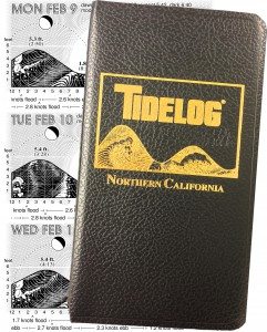
TIDELOG is more than just another tidechart!
TIDELOG© is a graphic almanac based on official National Oceanic and Atmospheric Administration (“NOAA”) and United States Naval Observatory (“USNO”) tide, current, and astronomical predictions specific to each geographical area. These areas are graphed to give you a visual picture of each day’s conditions… at a glance!
Tidelog’s graphics make it hard to go wrong. This is why Tidelog is favored not only by recreational boaters, but also by commercial, scientific and industrial users.
Repeat customers include many of the big names in shipping, tugboat, piloting, engineering, construction, flood control, pollution control, aquaculture, police, harbormaster and other maritime professions.
Tidelog eliminates the guesswork.
- Based on official NOAA and USNO predictions
- Teaches without words, quick at a glance view
- Favored by commercial, scientific and industrial users
- Built to last, tough and water resistant
- Minimizes mistakes, easy to interpret
- Custom imprint options available

Bring the numbers to life:
Tidelogs are drawn from NOAA predictions to give you a visual picture of each day’s conditions… in a quick, easy-to-read glance!

More than just a tidechart:
Tides and currents are presented in the context of the sun and moon, helping you make real-world assessments of the condition’s you’ll face.

Custom Imprinting:
Imprint Tidelogs with your business name or logo so your customers will have your information at their fingertips year round.

Accurate and trusted:
With access to NOAA’s latest cartographic changes, our charts are printed with the most accurate and relevant up to date information!
Pacific Publishers, LLC | P.O. Box 2813 | Tybee Island, GA 31328 | Phone: (912) 472-4373 | Fax: (912) 786-7921
Business Hours: Monday – Thursday 9:00am to 5:00pm Eastern
Questions, comments or interest in carrying our products? Contact us
Questions, comments or interest in carrying our products? Contact us
Pacific Publishers, LLC – P.O. Box 2813 – Tybee Island, GA 31328 – Phone: (912) 472-4373 – Fax: (912) 786-7921
Business Hours: Monday – Thursday 9:00am to 5:00pm Eastern
