Menu
Tidelogs
What is Tidelog?
Why Tidelog is better
Custom Imprinting
Tidelog FAQ
WEST COAST
Northern California (for SF BAY)
Puget Sound
Pacific Northwest
Coast of Northern CA
Suisun Bay & Delta
Monterey Bay
Morro Bay Tidelog
Southern California
EAST COAST
Northern New England
Eastport & Bar Harbor
Nantucket Island & Martha’s Vineyard
Southern New England
Long Island Sound
New York & New Jersey
Mid Atlantic
Chesapeake Tidewater
Southeastern
Savannah & Tybee Island
Close
Logs & Journals
Angler’s Log
Captain’s Log
Blank Journals
Lined Journals
Tidelog Journals
Close
Tidebooks
What are Tidebooks?
Our Tidebook Products
Tidebook FAQ
Get a Tidebook Quote
Close
Nautical Charts
About our Nautical Charts
Nautical Chart FAQ
NOAA Custom Charts
BY REGION
Alaska
East Coast
Great Lakes
Gulf Coast
West Coast
BY STATE
Alabama
Arizona
California
Delaware
Connecticut
Florida
Georgia
Maine
Michigan
Minnesota
North Carolina
New Hampshire
New Jersey
Rhode Island
Oregon
South Carolina
Washington
Wisconsin
Virginia
Close
About Us
Tidelog Tid(e)bits
Maritime Resource Locker
Close
What's really going on out there?
Home
/
NOAA Nautical Charts
/ Page 3
Showing 41–41 of 41 results
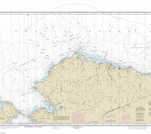
16003 – Arctic Coast
$
23.95
–
$
27.95
←
1
2
3